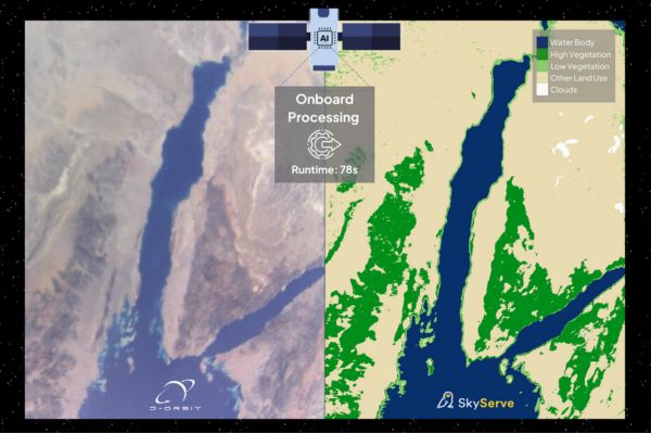
SkyServe, a leading space tech and a pioneer in edge computing technology company based in Bengaluru and Cupertino, announced that it has successfully achieved Smart Earth Imaging in orbit, marking a revolutionary step forward in the field of Earth observation.
STORM makes Satellites Smarter
In mid-April, SkyServe collaborated with space logistics company D-Orbit to uplink and test STORM, their edge computing software stack, on a satellite launched by SpaceX in January 2022. Within seconds of capturing a vast area over the Egypt-Sinai Peninsula, STORM performed a range of intelligent tasks on the satellite itself, including:
- Correcting errors in the imagery
- Detecting and removing cloud and water cover
- Identifying vegetation Following these onboard optimizations, STORM transmitted memory-efficient imaging by 5X, back to Earth.
This groundbreaking achievement demonstrates SkyServe’s ability to generate actionable insights in a fraction of time.
Beyond Traditional Earth Observation
STORM signifies a paradigm shift, empowering satellites to perform well beyond their original functionalities. The edge computing stack delivers near-real-time insights for customer applications, optimizing for specific use cases on-demand, enabling a dynamic and responsive approach to Earth observation. “We’re essentially creating the iPhone moment for Earth observation,” says Vinay Simha, SkyServe’s Co-founder and CEO, he added, “Just like Smartphones revolutionized data accessibility and enhanced user engagement, STORM hosts and enables geospatial applications with edge tasking and data processing, unlocking a vast array of use cases from space.”
Viney Jean-Francois Dhiri, D-Orbit’s Head of Business Development. “The collaboration with SkyServe not only facilitates their in-orbit STORM platform but also aligns with our mission to provide comprehensive in-orbit services.”
SkyServe’s Giant Leaps
SkyServe’s commitment to innovation extends beyond the mission Matterhorn onto Mission Denali, STORM’s capabilities on another satellite already in orbit, SkyServe leverages Loft Orbital’s YAM-6 satellite, launched earlier this year, to showcase automated tasking, hosting customer geospatial models for various use cases. “We can program the satellites to identify wildfires while flying over regions like Australia and monitor water resources when they are positioned over Bengaluru,” explains Vishesh Vatsal, SkyServe’s Co-founder and CTO. Later this year, SkyServe is gearing up for Mission K2 scheduled for launch aboard ISRO’s PSLV C59. These missions are empowering geospatial operations by enabling analytics companies with onboard data processing capabilities, unlocking a new paradigm of real-time insights from space.


