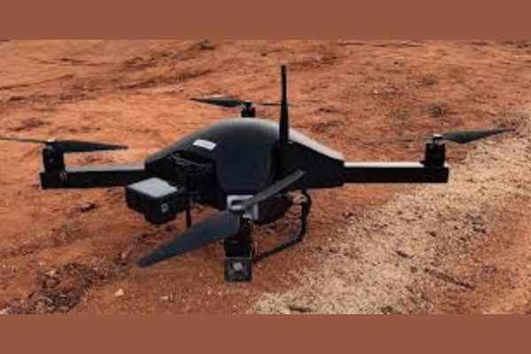
Drones’ rapid technological development has transformed many industries by offering creative answers to difficult problems. Surveyaan offers a comprehensive ecosystem comprising type-certified drones, advanced DGNSS solutions, and cloud-based photogrammetry software. A field that values accuracy and productivity needs this cutting-edge technology. This ecosystem caters to industries such as mining, surveying, construction, agriculture, and solar addressing the need for high-precision data and seamless operational integration. The key to the Surveyaan Drone is its ecosystem, providing accuracy, effectiveness, and scalability. This case study highlights the experiences of three clients- HK Associates (Udaipur), Asian GeoTech (Bhubaneswar), and Chinnasuri Enterprises (Hyderabad), who transformed their operations with our Drone ecosystem, achieving remarkable growth and operational excellence.
Challenges before Implementation
Many companies that use conventional techniques for data collection, mapping, and surveying face the following common problems:
- Conventional methods of surveying and mapping can be labour-intensive and thus time-consuming while imposing high operational costs.
- Human errors in manual operations or outdated technology would cause a delay, requiring either rework or added costs.
- Typically traditional methods struggle to accommodate large-scale projects that require rapid changes in project scope, resulting in the industry not being able to scale operations.
- Seamless integration of the data with the existing workflows of a company is a hindrance, considering that companies have always resorted to different software and systems not necessarily for integration.
Solution for Surveyaan’s Drone Ecosystem
Adopting Surveyaan’s Drone Ecosystem helped businesses obtain a complete solution for overcoming such issues:
- Type-Certified Drones: The drones developed by Surveyaan are certified as per local laws and regulations, ensuring reliable operations and accurate collection of data within a much shorter time compared to the traditional method.
- Cloud Photogrammetry Software: Surveyaan generates high-quality 3D models, contours, and actionable insights from drone-captured data, so businesses may leverage it to streamline operations and improve the quality of their decision-making.
- Integration Tools: The ecosystem ensures seamless data export in industry-standard formats (DXF, SHP), making it easy to integrate drone-collected data with existing workflows and software systems.
- Precision and Efficiency: DGNSS and drone technology integration will yield unmatched accuracy and speed in which businesses can get the volume calculation, stockpile measurement, or mapping done with minimal error and faster turnaround.
Impact on Business Growth and Operations
Businesses that adopted Surveyaan’s Drone Ecosystem saw improvements in several areas:
- Businesses were able to cut time and save money through data collection automation as well as by reducing the amount of time that would have otherwise been spent doing things manually. They would thus take on more projects and grow their businesses.
- With drone-based solutions, businesses can achieve higher accuracies, minimal errors, improved quality of output, and then enhance client trust and satisfaction that have been recorded.
- The rate at which data could be gathered and processed made it possible for businesses to turn projects around much faster, making it possible for higher revenue and greater operational scale.
- Surveyaan’s technology helped businesses scale their operations to fulfill project requirements based on their variant, without being constrained by the limitations of the traditional methods.
- The quality of actionable data generated through Surveyaan’s ecosystem allowed businesses to make faster, data-driven decisions that improve overall project outcomes.
Surveyaan’s Drone Ecosystem proved to be very rewarding for its customers, bringing huge returns on their investments. These results not only led to much shorter completion times of projects, reducing operating expenses but also handled more projects which added more revenues, increasing 4 times and businesses also managed to recoup the investment within a couple of months of embracing the technology.
Speaking about the revolutionary impact of the drone technology on business operations, Shubham Baranwal, Co-Founder and Director of Surveyaan said, “Surveyaan’s drone ecosystem is developed not only to meet the current demands of businesses but also to future-proof their operations. By offering unmatched precision, scalability and efficiency, we have helped businesses overcome the major challenges of traditional surveying. Our technology empowers companies to enhance their project timelines, increase profitability and make better, data-driven decisions.”
Conclusion
The Surveyaan Ecosystem has transformed operations across industries, so businesses can grow, enhance project results, and satisfy their clientele, by overcoming the limitations of the traditional methods. Businesses are out in the competition, and addressing their challenges, as they have all rights to expand their operations significantly due to the smooth integration of drone technology with cutting-edge geospatial analytics. The technology’s efficiency and precision offer a competitive edge in the geospatial industry, offering long-term success in a highly digitized world.
Their success story well depicts how drone surveying is revolutionizing industries and how innovation and efficiency go hand in hand. With the continued application of Surveyaan’s solutions, it is poised for further growth and long-term success.


